The GPS positioning system played a big role in the plant maintenance operation of the drone , but Xiaobian found that many people are not sure what the difference between GPS, Beidou satellite, Chihiro location and RTK is. What are their positioning principles? ? Don't worry, Xiaobian will come to you for a detailed analysis.
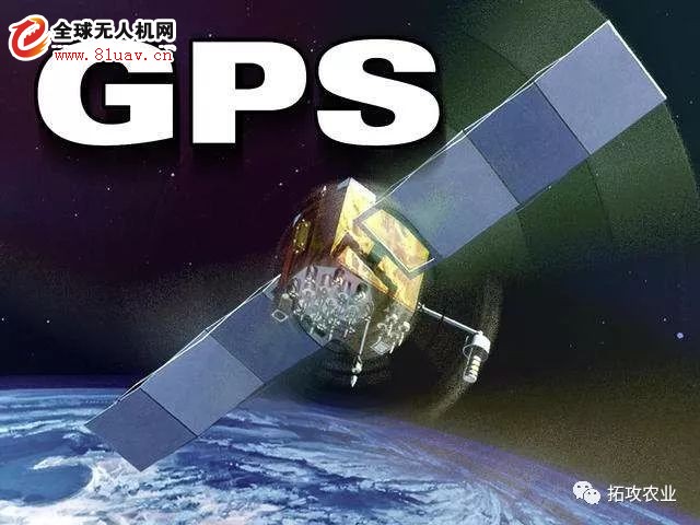
GPS
GPS: A system that uses GPS to locate satellites and locate and navigate in real time on a global scale. It is called Global Positioning System (GPS). GPS is an all-weather, all-weather, full-time, high-precision satellite navigation system developed by the US Department of Defense. It can provide global users with low-cost, high-precision navigation information such as three-dimensional position, speed and precise timing. The application model of satellite communication technology in the field of navigation has greatly improved the level of informationization of the earth society and effectively promoted the development of the digital economy.
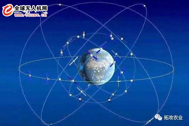
GPS positioning principle: 24 GPS satellites orbit the earth in a 12-hour period at an altitude of 12,000 kilometers from the ground, so that at any time, more than 4 satellites can be observed at any point on the ground. .
Since the position of the satellite is accurate, in the GPS observation, the distance from the satellite to the receiver, using the distance formula in the three-dimensional coordinates, using three satellites, can form three equations to solve the position of the observation point (X, Y, Z). Considering the error between the satellite's clock and the receiver's clock, there are actually four unknowns, X, Y, Z, and clock difference. Therefore, it is necessary to introduce the fourth satellite to form four equations to solve the problem. Latitude and longitude and elevation.
In fact, the receiver can often lock more than 4 satellites. In this case, the receiver can be divided into groups according to the constellation distribution of the satellite, each group of 4, and then the algorithm selects the group with the smallest error for positioning. Improve accuracy. The positioning used by the general public is mainly divided into GPS single point positioning, and the accuracy is meter level, 10 meters.
Beidou Satellite
Beidou satellite definition: It is China's independent research and development, using geosynchronous satellite to provide users with all-weather, regional satellite positioning. It is also the third mature satellite navigation system after the US Global Positioning System (GPS) and the Russian GLONASS satellite navigation system (GLONASS). The Beidou satellite navigation system consists of three parts: space segment, ground segment and user segment. It can provide high-precision, high-reliability positioning, navigation and timing services for all kinds of users all round the clock and all day in the world, and has short message communication. ability. The "Beidou No.1" satellite navigation and positioning system is not affected by communication signals and spatial distance. After a main commander performs satellite positioning, it can connect multiple "Beidou No.1" terminals similar to mobile phones. The terminal can be used every time. Writing more than 40 words of text messages to the designated mobile phone is very beneficial to the rescue information transmission in the earthquake zone.
Beidou satellite positioning principle: According to the received satellite signal, first calculate the position of the satellite, the distance between the satellite and the receiver. The two know that all possible positions of the receiver are the ball with the satellite as the center of the sphere. The intersection of the four balls is the position of the receiver. So in theory, at least four satellites can be used for positioning. Of course, at least three satellites can actually be positioned because another point away from the Earth's surface can be eliminated. The more satellites, the more accurate the positioning. A little different from GPS, Beidou users can communicate with satellites for short messages, but have transmission power requirements, so they are mainly used for vehicles and ships.
Chihiro location
Chihiro location definition: Chihiro location provides the nation's largest range of precision positioning services. At present, the US GPS navigation positioning accuracy used by the public is 5 to 10 meters, and the positioning accuracy of the mass navigation terminal compatible with the Beidou/GPS dual mode is mostly about 3 to 5 meters. The Chihiro position is already available through the ground enhancement system. Increase positioning accuracy to centimeters or even millimeters.
Chihiro location positioning principle: Chihiro location and GPS are different concepts; GPS is mainly positioned by satellite, without any positioning enhancement system, and because of signal error, the positioning accuracy is in meters; Chihiro location is built in various regions. Base station, and the purpose of the base station is mainly to modify the information error sent by the satellite to make the positioning more accurate; therefore, the position of the Chihiro needs to be accurately positioned with the satellite; the accuracy level is in the centimeter level. The Chihiro location will be introduced into the national CORS network, introducing a differential positioning system to correct the coordinates, and the accuracy can be sub-meter, centimeter.
Xiaobian tells you secretly, in fact, the extension has already connected to the Chihiro network location service very early, which makes the plant protection drones have the advantages of low cost, easy operation and high efficiency in agricultural applications.
RTK
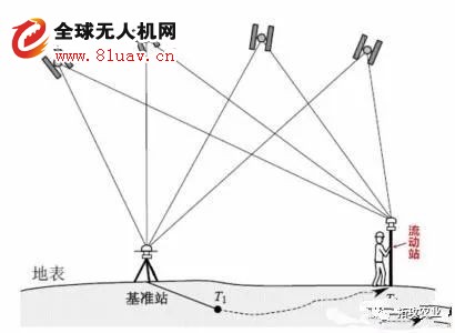
RTK definition: RTK (Real-time kinematic) carrier phase difference technology is a differential method for real-time processing of carrier phase observations of two measurement stations. The carrier phase acquired by the base station is sent to the user receiver for differential solution. Calculate the coordinates. This is a new commonly used GPS measurement method. Previous static, fast static and dynamic measurements require post-calculation to achieve centimeter-level accuracy, while RTK is a measurement method that can obtain centimeter-level positioning accuracy in real time in the field. It adopts the carrier phase dynamic real-time differential method, which is a major milestone of GPS application. Its appearance is engineering lofting, topographic mapping, and various control measurements bring a new dawn, greatly improving the efficiency of field operations.
RTK positioning principle: the base station is built on known or unknown points; the satellite signals received by the base station are sent to the user in real time through the wireless communication network; the user receiver combines the received satellite signals with the received base station signals in real time. Find the coordinate increment between the base station and the rover (baseline vector). The station spacing is 30 kilometers and the plane accuracy is 1-2 cm. RTK is a real-time dynamic differential with an accuracy of centimeter, which means that RTK is an application method of GPS.
I believe that you have a preliminary understanding of these four types of positioning, the following small series focus on, let us fly the anti-phytosanitary staff commonly used RTK, what are the advantages?
Advantages of RTK technology
1, high efficiency
Under the general topographical terrain, the high-quality RTK station can measure the 5km radius of the measurement area at one time, greatly reducing the number of control points required for traditional measurement and the number of "moving stations" of the measuring instrument, requiring only one person to operate. Each stakeout point only needs to stay for 1-2 seconds to complete the job, and its accuracy and efficiency are unmatched by conventional measurements.
2, high positioning accuracy, no error accumulation
As long as the basic working conditions of the RTK are met, the plane accuracy and elevation accuracy of the RTK can reach centimeter level within a certain working radius (usually 5 km), and there is no error accumulation.
3, all-weather operation
RTK technology does not require optical communication between two points, and only needs to meet the requirements of "electromagnetic wave through and air-to-air viewing". Therefore, compared with traditional measurement, RTK technology has fewer restrictions on operation and can be operated almost all day.
4, RTK operation automation, integration is high
RTK is competent for a variety of mapping industries. The rover is equipped with an efficient handheld operation book. The built-in professional software can automatically realize a variety of mapping functions, reducing human error and ensuring the accuracy of the work.
Posh Plus,Posh Plus Xl Pod Vape,Posh Plus Disposable Vape,Posh Plus Disposable Pod Device
Shenzhen Zpal Technology Co.,Ltd , https://www.zpalvapes.com